


fêtes des vins st peray

olivier26
User
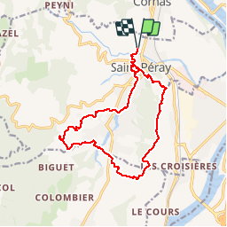

Length
16.9 km

Max alt
388 m

Uphill gradient
492 m
Km-Effort
23 km

Min alt
130 m

Downhill gradient
492 m
Boucle
Yes
Creation date :
2014-12-10 00:00:00.0
Updated on :
2014-12-10 00:00:00.0
4h03
Difficulty : Easy

FREE GPS app for hiking
 SityTrail
IGN / Geographical institutes
SityTrail Plus
The world is yours!
About
Trail Walking of 16.9 km to be discovered at Auvergne-Rhône-Alpes, Ardèche, Saint-Péray. This trail is proposed by olivier26.
Description
parcours de 15 kms
Positioning
Country:
France
Region :
Auvergne-Rhône-Alpes
Department/Province :
Ardèche
Municipality :
Saint-Péray
Location:
Unknown
Start:(Dec)
Start:(UTM)
645295 ; 4979121 (31T) N.
Comments