


Maidières Blenod

RobertO54
User
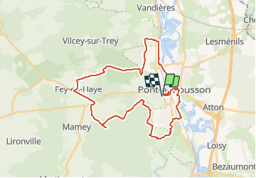

Length
35 km

Max alt
378 m

Uphill gradient
499 m
Km-Effort
42 km

Min alt
175 m

Downhill gradient
499 m
Boucle
Yes
Creation date :
2019-08-22 14:17:49.607
Updated on :
2019-08-22 16:32:14.997
2h09
Difficulty : Medium

FREE GPS app for hiking
 SityTrail
IGN / Geographical institutes
SityTrail Plus
The world is yours!
About
Trail Mountain bike of 35 km to be discovered at Grand Est, Meurthe-et-Moselle, Maidières. This trail is proposed by RobertO54.
Positioning
Country:
France
Region :
Grand Est
Department/Province :
Meurthe-et-Moselle
Municipality :
Maidières
Location:
Unknown
Start:(Dec)
Start:(UTM)
283301 ; 5420334 (32U) N.
Comments