


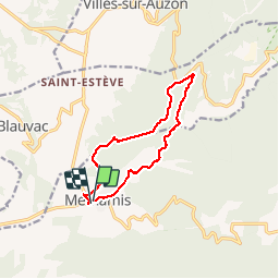
Méthamis (autour)

MarcLEBARON
User

Length
10.9 km

Max alt
473 m

Uphill gradient
307 m
Km-Effort
15 km

Min alt
263 m

Downhill gradient
318 m
Boucle
Yes
Creation date :
2014-12-10 00:00:00.0
Updated on :
2014-12-10 00:00:00.0
2h21
Difficulty : Easy

FREE GPS app for hiking
 SityTrail
IGN / Geographical institutes
SityTrail Plus
The world is yours!
About
Trail Walking of 10.9 km to be discovered at Provence-Alpes-Côte d'Azur, Vaucluse, Méthamis. This trail is proposed by MarcLEBARON.
Description
Boucle
Positioning
Country:
France
Region :
Provence-Alpes-Côte d'Azur
Department/Province :
Vaucluse
Municipality :
Méthamis
Location:
Unknown
Start:(Dec)
Start:(UTM)
678000 ; 4875745 (31T) N.
Comments
Après avoir traversé le village, la randonnée rejoint le lit à sec de la Nesque. Le cheminement se fait sur les alluvions grossiers du lit (allègrement tassés par des traces de véhicule...). Au bout de 4 km environ quitté le lit par la gauche et rejoindre la D 942 par une piste et un sentier terminal.Redescente sur Méthamis par le début du Gr91 et le PR qui s'en écarte (attention la partie rectiligne au milieu de limite de commune présente un descente un peu raide et pierreure dans un talweg et remontée identique, c'est pour cela que le PR l'évite).Après la dernière balise prendre un sentier peu marquée sur la droite pour rejoindre Méthamis.