


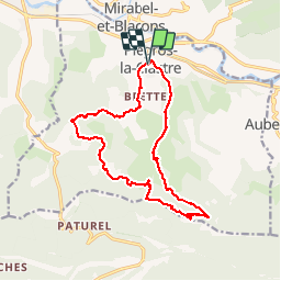
Le Clastres - Chapelle Saint Bernard

maupassant38
User

Length
16.8 km

Max alt
840 m

Uphill gradient
794 m
Km-Effort
27 km

Min alt
231 m

Downhill gradient
795 m
Boucle
Yes
Creation date :
2019-08-24 07:40:26.981
Updated on :
2019-08-24 13:46:47.06
5h06
Difficulty : Medium

FREE GPS app for hiking
 SityTrail
IGN / Geographical institutes
SityTrail Plus
The world is yours!
About
Trail Walking of 16.8 km to be discovered at Auvergne-Rhône-Alpes, Drôme, Piégros-la-Clastre. This trail is proposed by maupassant38.
Positioning
Country:
France
Region :
Auvergne-Rhône-Alpes
Department/Province :
Drôme
Municipality :
Piégros-la-Clastre
Location:
Unknown
Start:(Dec)
Start:(UTM)
666142 ; 4951635 (31T) N.
Comments