


Montjoie le Château

TRIMAILLE
User
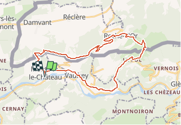

Length
18.9 km

Max alt
905 m

Uphill gradient
751 m
Km-Effort
29 km

Min alt
396 m

Downhill gradient
752 m
Boucle
Yes
Creation date :
2019-08-24 17:19:10.281
Updated on :
2019-08-24 17:20:37.994
5h59
Difficulty : Very difficult

FREE GPS app for hiking
 SityTrail
IGN / Geographical institutes
SityTrail Plus
The world is yours!
About
Trail Walking of 18.9 km to be discovered at Bourgogne-Franche-Comté, Doubs, Montjoie-le-Château. This trail is proposed by TRIMAILLE.
Positioning
Country:
France
Region :
Bourgogne-Franche-Comté
Department/Province :
Doubs
Municipality :
Montjoie-le-Château
Location:
Unknown
Start:(Dec)
Start:(UTM)
341551 ; 5245899 (32T) N.
Comments