


balade ton bleu des amis de la côte

stef789
User GUIDE
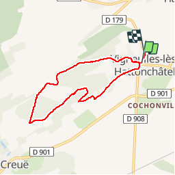

Length
6.5 km

Max alt
376 m

Uphill gradient
133 m
Km-Effort
8.2 km

Min alt
256 m

Downhill gradient
133 m
Boucle
No
Creation date :
2019-08-25 10:48:04.45
Updated on :
2019-08-25 13:02:02.614
1h35
Difficulty : Very easy

FREE GPS app for hiking
 SityTrail
IGN / Geographical institutes
SityTrail Plus
The world is yours!
About
Trail Walking of 6.5 km to be discovered at Grand Est, Meuse, Vigneulles-lès-Hattonchâtel. This trail is proposed by stef789.
Photos


Positioning
Country:
France
Region :
Grand Est
Department/Province :
Meuse
Municipality :
Vigneulles-lès-Hattonchâtel
Location:
Vigneulles-lès-Hattonchâtel
Start:(Dec)
Start:(UTM)
697755 ; 5428882 (31U) N.
Comments
cool