Trail Walking Glanville - 2019-08-26 Rando Glanville - la butte clara - Photo

2019-08-26 Rando Glanville - la butte clara

© OpenStreetMap contributors
Length
Length
8.6 km
Max alt
Max alt
130 m
Uphill gradient
Uphill gradient
203 m
Km-Effort
Km-Effort  
11.3 km
Min alt
Min alt
58 m
Downhill gradient
Downhill gradient
204 m
Boucle
Boucle
Yes
Creation date :
2019-08-26 07:25:59.454
Updated on :
2019-08-26 14:56:30.815

(1 Reviews)

Walking
Walking
2h55
Difficulty : Easy

Scan this QR Code to open this trail in the SityTrail application

FREE GPS app for hiking

Logo SityTrail SityTrail

IGN / Geographical institutes

Download SityTrail from the App Store Download SityTrail from Google Play

Logo SityTrail SityTrail Plus

The world is yours!

Download SityTrail from the App Store Download SityTrail from Google Play Download SityTrail on Huawei AppGallery

About

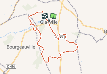
Trail Walking of 8.6 km to be discovered at Normandy, Calvados, Glanville. This trail is proposed by jchezlemas.

Description

parking à la mairie
après Resto pour se remettre
Le Clos des Pommiers
http://www.gonnevillesurmer.fr/a-gonneville-sur-mer/gonneville-sur-mer/restauration/le-clos-des-pommiers/
ou La Tornade
https://www.brasserie-latornade.fr/

Elevation profile

Positioning

Country:
France
Region :
Normandy
Department/Province :
Calvados
Municipality :
Glanville
Location:
Unknown
Start:(UTM)
287010 ; 5462991 (31U) N.

Comments

Please log in to post a review or rate the element


ok ça grimpe


Close
My subscriptions