


bourlatier m'ont gerbier

raab
User
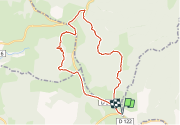

Length
9.7 km

Max alt
1455 m

Uphill gradient
226 m
Km-Effort
12.7 km

Min alt
1292 m

Downhill gradient
226 m
Boucle
Yes
Creation date :
2019-08-26 07:29:26.504
Updated on :
2019-08-26 10:55:24.025
3h25
Difficulty : Easy

FREE GPS app for hiking
 SityTrail
IGN / Geographical institutes
SityTrail Plus
The world is yours!
About
Trail Walking of 9.7 km to be discovered at Auvergne-Rhône-Alpes, Ardèche, Saint-Andéol-de-Fourchades. This trail is proposed by raab.
Positioning
Country:
France
Region :
Auvergne-Rhône-Alpes
Department/Province :
Ardèche
Municipality :
Saint-Andéol-de-Fourchades
Location:
Unknown
Start:(Dec)
Start:(UTM)
598259 ; 4963581 (31T) N.
Comments