


bugarach par col linas

leroj73
User
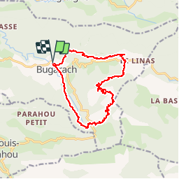

Length
17.3 km

Max alt
1215 m

Uphill gradient
870 m
Km-Effort
29 km

Min alt
458 m

Downhill gradient
870 m
Boucle
Yes
Creation date :
2019-08-26 08:36:33.265
Updated on :
2019-08-26 14:24:52.053
4h47
Difficulty : Very easy

FREE GPS app for hiking
 SityTrail
IGN / Geographical institutes
SityTrail Plus
The world is yours!
About
Trail Walking of 17.3 km to be discovered at Occitania, Aude, Bugarach. This trail is proposed by leroj73.
Description
joli parcours. descente technique et glissante par l autre côté
Photos


Positioning
Country:
France
Region :
Occitania
Department/Province :
Aude
Municipality :
Bugarach
Location:
Unknown
Start:(Dec)
Start:(UTM)
446847 ; 4747448 (31T) N.
Comments