


le phare de bornes

raab
User
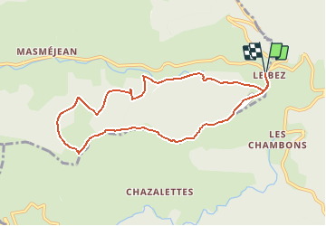

Length
8.9 km

Max alt
1356 m

Uphill gradient
355 m
Km-Effort
13.6 km

Min alt
1118 m

Downhill gradient
355 m
Boucle
Yes
Creation date :
2019-08-26 16:12:58.124
Updated on :
2019-08-26 16:14:12.372
2h49
Difficulty : Difficult

FREE GPS app for hiking
 SityTrail
IGN / Geographical institutes
SityTrail Plus
The world is yours!
About
Trail Walking of 8.9 km to be discovered at Auvergne-Rhône-Alpes, Ardèche, Borne. This trail is proposed by raab.
Positioning
Country:
France
Region :
Auvergne-Rhône-Alpes
Department/Province :
Ardèche
Municipality :
Borne
Location:
Unknown
Start:(Dec)
Start:(UTM)
583328 ; 4943315 (31T) N.
Comments