


NAILLOUX

CANON2
User
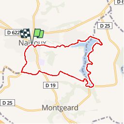

Length
7.8 km

Max alt
293 m

Uphill gradient
160 m
Km-Effort
9.9 km

Min alt
205 m

Downhill gradient
164 m
Boucle
Yes
Creation date :
2019-05-15 13:09:33.488
Updated on :
2019-05-15 13:09:33.528
2h09
Difficulty : Very easy

FREE GPS app for hiking
 SityTrail
IGN / Geographical institutes
SityTrail Plus
The world is yours!
About
Trail Walking of 7.8 km to be discovered at Occitania, Haute-Garonne, Nailloux. This trail is proposed by CANON2.
Positioning
Country:
France
Region :
Occitania
Department/Province :
Haute-Garonne
Municipality :
Nailloux
Location:
Unknown
Start:(Dec)
Start:(UTM)
388452 ; 4801204 (31T) N.
Comments