


Patigons et la Conche

janussity
User
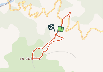

Length
3.8 km

Max alt
1504 m

Uphill gradient
96 m
Km-Effort
5.1 km

Min alt
1440 m

Downhill gradient
99 m
Boucle
Yes
Creation date :
2019-08-27 16:11:19.773
Updated on :
2019-08-27 17:50:05.788
1h38
Difficulty : Very easy

FREE GPS app for hiking
 SityTrail
IGN / Geographical institutes
SityTrail Plus
The world is yours!
About
Trail Walking of 3.8 km to be discovered at Provence-Alpes-Côte d'Azur, Alpes-de-Haute-Provence, Enchastrayes. This trail is proposed by janussity.
Description
balade digestive très facile
Positioning
Country:
France
Region :
Provence-Alpes-Côte d'Azur
Department/Province :
Alpes-de-Haute-Provence
Municipality :
Enchastrayes
Location:
Unknown
Start:(Dec)
Start:(UTM)
316994 ; 4917138 (32T) N.
Comments