SityTrail - St Bonnet le Froid 2

Coux
User

Length
16.3 km

Max alt
842 m

Uphill gradient
721 m
Km-Effort
26 km

Min alt
457 m

Downhill gradient
721 m
Boucle
Yes
Creation date :
2019-08-28 05:18:41.402
Updated on :
2019-08-28 05:22:19.047
5h21
Difficulty : Very difficult

FREE GPS app for hiking
 SityTrail
IGN / Geographical institutes
SityTrail Plus
The world is yours!
About
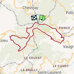
Trail Walking of 16.3 km to be discovered at Auvergne-Rhône-Alpes, Rhône, Courzieu. This trail is proposed by Coux.
Description
quelques montées soutenues
Positioning
Country:
France
Region :
Auvergne-Rhône-Alpes
Department/Province :
Rhône
Municipality :
Courzieu
Location:
Unknown
Start:(Dec)
Start:(UTM)
625753 ; 5068245 (31T) N.
Comments