


Choisy

corynne
User
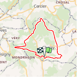

Length
14.3 km

Max alt
771 m

Uphill gradient
374 m
Km-Effort
19.3 km

Min alt
446 m

Downhill gradient
376 m
Boucle
Yes
Creation date :
2019-08-28 06:51:32.863
Updated on :
2019-08-28 10:12:37.155
3h19
Difficulty : Very easy

FREE GPS app for hiking
 SityTrail
IGN / Geographical institutes
SityTrail Plus
The world is yours!
About
Trail Nordic walking of 14.3 km to be discovered at Auvergne-Rhône-Alpes, Upper Savoy, Choisy. This trail is proposed by corynne.
Positioning
Country:
France
Region :
Auvergne-Rhône-Alpes
Department/Province :
Upper Savoy
Municipality :
Choisy
Location:
Unknown
Start:(Dec)
Start:(UTM)
271775 ; 5096657 (32T) N.
Comments