


champignon tincave

franquen
User
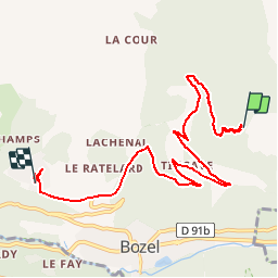

Length
8.9 km

Max alt
1745 m

Uphill gradient
65 m
Km-Effort
11.9 km

Min alt
1052 m

Downhill gradient
702 m
Boucle
No
Creation date :
2019-08-28 10:42:06.883
Updated on :
2019-08-28 13:11:06.836
2h27
Difficulty : Very easy

FREE GPS app for hiking
 SityTrail
IGN / Geographical institutes
SityTrail Plus
The world is yours!
About
Trail Hunting of 8.9 km to be discovered at Auvergne-Rhône-Alpes, Savoy, Bozel. This trail is proposed by franquen.
Positioning
Country:
France
Region :
Auvergne-Rhône-Alpes
Department/Province :
Savoy
Municipality :
Bozel
Location:
Unknown
Start:(Dec)
Start:(UTM)
317462 ; 5036267 (32T) N.
Comments