


Arrênes-la Sout

csy95
User
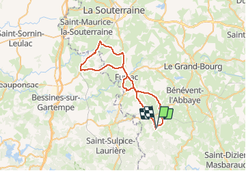

Length
49 km

Max alt
441 m

Uphill gradient
653 m
Km-Effort
57 km

Min alt
319 m

Downhill gradient
655 m
Boucle
Yes
Creation date :
2019-08-25 07:03:06.021
Updated on :
2019-08-28 16:12:15.939
3h03
Difficulty : Medium

FREE GPS app for hiking
 SityTrail
IGN / Geographical institutes
SityTrail Plus
The world is yours!
About
Trail Road bike of 49 km to be discovered at New Aquitaine, Creuse, Arrènes. This trail is proposed by csy95.
Positioning
Country:
France
Region :
New Aquitaine
Department/Province :
Creuse
Municipality :
Arrènes
Location:
Unknown
Start:(Dec)
Start:(UTM)
389558 ; 5103210 (31T) N.
Comments