
Belluny , Chapelle de St. Cassien, Lac de St Cassien

verotrail
User
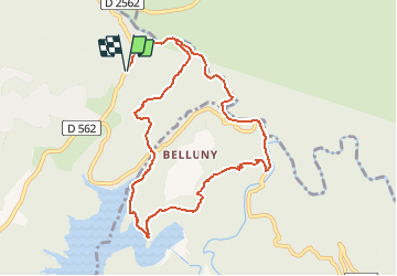

Length
10.8 km

Max alt
285 m

Uphill gradient
390 m
Km-Effort
16 km

Min alt
70 m

Downhill gradient
390 m
Boucle
Yes
Creation date :
2019-08-29 15:05:22.791
Updated on :
2020-02-04 15:03:44.489
--
Difficulty : Medium

FREE GPS app for hiking
 SityTrail
IGN / Geographical institutes
SityTrail Plus
The world is yours!
About
Trail On foot of 10.8 km to be discovered at Provence-Alpes-Côte d'Azur, Var, Montauroux. This trail is proposed by verotrail.
Photos


Positioning
Country:
France
Region :
Provence-Alpes-Côte d'Azur
Department/Province :
Var
Municipality :
Montauroux
Location:
Unknown
Start:(Dec)
Start:(UTM)
324371 ; 4831770 (32T) N.
Comments