


2019 08 BOISSY LE CUTTE T1

michel1025
User
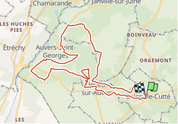

Length
24 km

Max alt
151 m

Uphill gradient
371 m
Km-Effort
29 km

Min alt
70 m

Downhill gradient
371 m
Boucle
Yes
Creation date :
2019-08-29 07:55:44.0
Updated on :
2019-08-29 15:33:04.686
5h54
Difficulty : Unknown

FREE GPS app for hiking
 SityTrail
IGN / Geographical institutes
SityTrail Plus
The world is yours!
About
Trail Walking of 24 km to be discovered at Ile-de-France, Essonne, Boissy-le-Cutté. This trail is proposed by michel1025.
Positioning
Country:
France
Region :
Ile-de-France
Department/Province :
Essonne
Municipality :
Boissy-le-Cutté
Location:
Unknown
Start:(Dec)
Start:(UTM)
446992 ; 5368803 (31U) N.
Comments