


Refuge Fontanalbe Mont Ste Marie Casterino

domi06
User
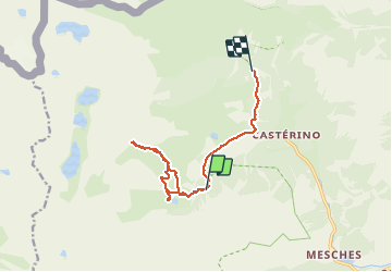

Length
11.9 km

Max alt
2717 m

Uphill gradient
774 m
Km-Effort
23 km

Min alt
1707 m

Downhill gradient
1081 m
Boucle
No
Creation date :
2019-08-23 06:10:30.315
Updated on :
2019-08-30 14:56:38.283
--
Difficulty : Medium

FREE GPS app for hiking
 SityTrail
IGN / Geographical institutes
SityTrail Plus
The world is yours!
About
Trail Walking of 11.9 km to be discovered at Provence-Alpes-Côte d'Azur, Maritime Alps, Tende. This trail is proposed by domi06.
Description
Direction la voie sacrée. Montée dans un couloir. Peu de caïrns.
Photos


Positioning
Country:
France
Region :
Provence-Alpes-Côte d'Azur
Department/Province :
Maritime Alps
Municipality :
Tende
Location:
Unknown
Start:(Dec)
Start:(UTM)
378374 ; 4882580 (32T) N.
Comments