


Regordane 1 - Costaros - Langogne

nolsim
User
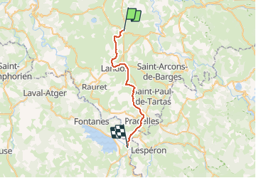

Length
27 km

Max alt
1237 m

Uphill gradient
377 m
Km-Effort
32 km

Min alt
899 m

Downhill gradient
546 m
Boucle
No
Creation date :
2019-08-30 07:02:41.466
Updated on :
2019-08-30 14:08:09.199
7h04
Difficulty : Medium

FREE GPS app for hiking
 SityTrail
IGN / Geographical institutes
SityTrail Plus
The world is yours!
About
Trail Walking of 27 km to be discovered at Auvergne-Rhône-Alpes, Haute-Loire, Costaros. This trail is proposed by nolsim.
Description
Peu de dénivelé. Chemin large.
Photos


Positioning
Country:
France
Region :
Auvergne-Rhône-Alpes
Department/Province :
Haute-Loire
Municipality :
Costaros
Location:
Unknown
Start:(Dec)
Start:(UTM)
567077 ; 4971630 (31T) N.
Comments