


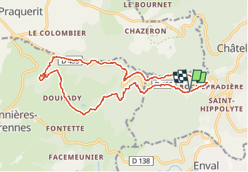
Rochepradiere Douhady

Gegetop
User

Length
10 km

Max alt
731 m

Uphill gradient
286 m
Km-Effort
13.8 km

Min alt
464 m

Downhill gradient
286 m
Boucle
Yes
Creation date :
2019-08-29 06:27:20.787
Updated on :
2019-08-30 16:06:30.934
2h20
Difficulty : Easy

FREE GPS app for hiking
 SityTrail
IGN / Geographical institutes
SityTrail Plus
The world is yours!
About
Trail Nordic walking of 10 km to be discovered at Auvergne-Rhône-Alpes, Puy-de-Dôme, Châtel-Guyon. This trail is proposed by Gegetop.
Positioning
Country:
France
Region :
Auvergne-Rhône-Alpes
Department/Province :
Puy-de-Dôme
Municipality :
Châtel-Guyon
Location:
Unknown
Start:(Dec)
Start:(UTM)
503580 ; 5084355 (31T) N.
Comments