


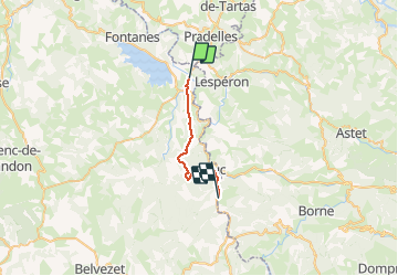
Régordane 2 - Langogne-Laveyrune

nolsim
User

Length
19.4 km

Max alt
1237 m

Uphill gradient
458 m
Km-Effort
25 km

Min alt
902 m

Downhill gradient
386 m
Boucle
No
Creation date :
2019-08-31 06:13:50.656
Updated on :
2019-08-31 12:08:49.642
5h52
Difficulty : Medium

FREE GPS app for hiking
 SityTrail
IGN / Geographical institutes
SityTrail Plus
The world is yours!
About
Trail Walking of 19.4 km to be discovered at Occitania, Lozère, Langogne. This trail is proposed by nolsim.
Description
Belle rando. Dénivelé un peu sportif
Positioning
Country:
France
Region :
Occitania
Department/Province :
Lozère
Municipality :
Langogne
Location:
Unknown
Start:(Dec)
Start:(UTM)
567896 ; 4953751 (31T) N.
Comments