


30.08.2018 - Col du wettstein - Forlet - Lac Noir - Col du Wettstein

delm
User
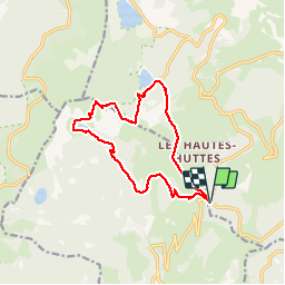

Length
13.1 km

Max alt
1273 m

Uphill gradient
508 m
Km-Effort
19.9 km

Min alt
850 m

Downhill gradient
507 m
Boucle
Yes
Creation date :
2019-08-31 09:36:00.0
Updated on :
2019-09-16 11:53:47.136
3h59
Difficulty : Difficult

FREE GPS app for hiking
 SityTrail
IGN / Geographical institutes
SityTrail Plus
The world is yours!
About
Trail Walking of 13.1 km to be discovered at Grand Est, Haut-Rhin, Orbey. This trail is proposed by delm.
Description
Randonnée sympathique et agréable
Montée du Forlet au crêtes assez difficile
Positioning
Country:
France
Region :
Grand Est
Department/Province :
Haut-Rhin
Municipality :
Orbey
Location:
Unknown
Start:(Dec)
Start:(UTM)
359751 ; 5327723 (32U) N.
Comments