


morthemer

Arnaud Dejean
User

Length
12.9 km

Max alt
139 m

Uphill gradient
217 m
Km-Effort
15.7 km

Min alt
77 m

Downhill gradient
184 m
Boucle
No
Creation date :
2019-08-31 13:13:08.275
Updated on :
2019-08-31 15:12:38.483
1h58
Difficulty : Very easy

FREE GPS app for hiking
 SityTrail
IGN / Geographical institutes
SityTrail Plus
The world is yours!
About
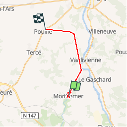
Trail Walking of 12.9 km to be discovered at New Aquitaine, Vienne, Valdivienne. This trail is proposed by Arnaud Dejean.
Photos


Positioning
Country:
France
Region :
New Aquitaine
Department/Province :
Vienne
Municipality :
Valdivienne
Location:
Unknown
Start:(Dec)
Start:(UTM)
316693 ; 5149465 (31T) N.
Comments