


010919 pic IV MONTCHENOT sermiers

cmar
User
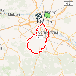

Length
34 km

Max alt
232 m

Uphill gradient
377 m
Km-Effort
39 km

Min alt
74 m

Downhill gradient
380 m
Boucle
No
Creation date :
2019-09-01 09:14:40.0
Updated on :
2019-09-01 12:15:35.382
3h01
Difficulty : Unknown

FREE GPS app for hiking
 SityTrail
IGN / Geographical institutes
SityTrail Plus
The world is yours!
About
Trail Road bike of 34 km to be discovered at Grand Est, Marne, Reims. This trail is proposed by cmar.
Positioning
Country:
France
Region :
Grand Est
Department/Province :
Marne
Municipality :
Reims
Location:
Unknown
Start:(Dec)
Start:(UTM)
574657 ; 5456170 (31U) N.
Comments