


RADEPONT

hugonemo
User
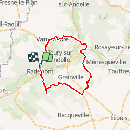

Length
23 km

Max alt
145 m

Uphill gradient
440 m
Km-Effort
29 km

Min alt
23 m

Downhill gradient
440 m
Boucle
Yes
Creation date :
2019-09-01 18:57:48.566
Updated on :
2019-09-01 19:24:14.03
--
Difficulty : Difficult

FREE GPS app for hiking
 SityTrail
IGN / Geographical institutes
SityTrail Plus
The world is yours!
About
Trail Walking of 23 km to be discovered at Normandy, Eure, Radepont. This trail is proposed by hugonemo.
Description
départ mairie de Radepont 22km
Positioning
Country:
France
Region :
Normandy
Department/Province :
Eure
Municipality :
Radepont
Location:
Unknown
Start:(Dec)
Start:(UTM)
378460 ; 5468084 (31U) N.
Comments