


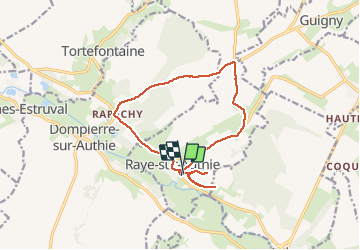
raye sur authie

Martelpierre
User

Length
12.6 km

Max alt
97 m

Uphill gradient
184 m
Km-Effort
15.1 km

Min alt
14 m

Downhill gradient
179 m
Boucle
Yes
Creation date :
2019-09-02 15:45:00.961
Updated on :
2019-09-02 17:22:11.594
1h08
Difficulty : Very easy

FREE GPS app for hiking
 SityTrail
IGN / Geographical institutes
SityTrail Plus
The world is yours!
About
Trail Road bike of 12.6 km to be discovered at Hauts-de-France, Pas-de-Calais, Raye-sur-Authie. This trail is proposed by Martelpierre.
Description
par fond de val et le fedoye et deux incursion dans parties est goudronnées à partir du cimetière.
Positioning
Country:
France
Region :
Hauts-de-France
Department/Province :
Pas-de-Calais
Municipality :
Raye-sur-Authie
Location:
Unknown
Start:(Dec)
Start:(UTM)
425249 ; 5572008 (31U) N.
Comments