


2019-09-02_21h00m35_A6313AUV063V5084MZ

jeanic63
User
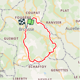

Length
11.6 km

Max alt
824 m

Uphill gradient
383 m
Km-Effort
16.6 km

Min alt
598 m

Downhill gradient
377 m
Boucle
Yes
Creation date :
2019-09-02 19:00:36.195
Updated on :
2019-09-07 16:15:03.089
--
Difficulty : Medium

FREE GPS app for hiking
 SityTrail
IGN / Geographical institutes
SityTrail Plus
The world is yours!
About
Trail On foot of 11.6 km to be discovered at Auvergne-Rhône-Alpes, Puy-de-Dôme, Brousse. This trail is proposed by jeanic63.
Description
départ église de Brousse 63 Puy de Dome
Positioning
Country:
France
Region :
Auvergne-Rhône-Alpes
Department/Province :
Puy-de-Dôme
Municipality :
Brousse
Location:
Unknown
Start:(Dec)
Start:(UTM)
535810 ; 5049872 (31T) N.
Comments