


Circuit Sorinnes à Thynes

dodobernier
User
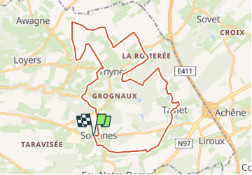

Length
19.4 km

Max alt
301 m

Uphill gradient
370 m
Km-Effort
24 km

Min alt
188 m

Downhill gradient
371 m
Boucle
Yes
Creation date :
2019-09-03 08:58:35.267
Updated on :
2023-07-23 08:19:27.502
5h32
Difficulty : Very difficult
1h36
Difficulty : Medium

FREE GPS app for hiking
 SityTrail
IGN / Geographical institutes
SityTrail Plus
The world is yours!
About
Trail Walking of 19.4 km to be discovered at Wallonia, Namur, Dinant. This trail is proposed by dodobernier.
Positioning
Country:
Belgium
Region :
Wallonia
Department/Province :
Namur
Municipality :
Dinant
Location:
Unknown
Start:(Dec)
Start:(UTM)
641057 ; 5569352 (31U) N.
Comments