


croit sur ourcq

bruno38
User
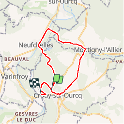

Length
11.7 km

Max alt
111 m

Uphill gradient
128 m
Km-Effort
13.5 km

Min alt
55 m

Downhill gradient
135 m
Boucle
No
Creation date :
2019-09-03 06:40:12.37
Updated on :
2019-09-03 09:20:37.047
2h39
Difficulty : Very easy

FREE GPS app for hiking
 SityTrail
IGN / Geographical institutes
SityTrail Plus
The world is yours!
About
Trail Walking of 11.7 km to be discovered at Ile-de-France, Seine-et-Marne, Crouy-sur-Ourcq. This trail is proposed by bruno38.
Description
marais de negando
Positioning
Country:
France
Region :
Ile-de-France
Department/Province :
Seine-et-Marne
Municipality :
Crouy-sur-Ourcq
Location:
Unknown
Start:(Dec)
Start:(UTM)
505167 ; 5437819 (31U) N.
Comments