Trail Walking Saint-Augustin-de-Woburn - 2015-04-19 15:00:20 - Photo
 Alizée.pee
Alizée.pee

User GUIDE

© OpenStreetMap contributors
Length
Length
13.4 km
Max alt
Max alt
1179 m
Uphill gradient
Uphill gradient
647 m
Km-Effort
Km-Effort  
22 km
Min alt
Min alt
575 m
Downhill gradient
Downhill gradient
647 m
Boucle
Boucle
Yes
Creation date :
2019-09-03 12:43:53.554
Updated on :
2019-09-03 12:45:01.731

(0 Reviews)

Walking
Walking
4h31
Difficulty : Medium

Scan this QR Code to open this trail in the SityTrail application

FREE GPS app for hiking

Logo SityTrail SityTrail

IGN / Geographical institutes

Download SityTrail from the App Store Download SityTrail from Google Play

Logo SityTrail SityTrail World

The world is yours!

Download SityTrail from the App Store Download SityTrail from Google Play Download SityTrail on Huawei AppGallery

About

Trail Walking of 13.4 km to be discovered at Quebec, Le Granit, Saint-Augustin-de-Woburn. This trail is proposed by Alizée.pee.

Description

Le mont Gosford est l’un des plus hauts sommets du Québec mais est malheureusement peu connu des randonneurs. Le sentier n’est pas des plus difficile mais il monte quand même. La dernière partie du sentier, la montée finale, est tout simplement magnifique. Au sommet de cette montagne, ce trouve une tour d’observation où il est possible de contempler un panorama à couper le souffle. Il est possible d’observer le fameux Mont Mégantic ainsi que son lac. Il est préférable de regarder les horaires d’ouverture du site avant de vous y rendre car celui-ci ferme durant les périodes de chasses.

Elevation profile

Points of interest

Point of interest Saint-Augustin-de-Woburn - Stationnement - Photo
Alizée.pee
SAINT-AUGUSTIN-DE-WOBURN 
Point of interest Saint-Augustin-de-Woburn - Sommet - Gosford - Photo
Alizée.pee
SAINT-AUGUSTIN-DE-WOBURN 
Point of interest Saint-Augustin-de-Woburn - Intersection 2 - Photo
Alizée.pee
SAINT-AUGUSTIN-DE-WOBURN 
Point of interest Saint-Augustin-de-Woburn - Intersection 1 - Photo
Alizée.pee
SAINT-AUGUSTIN-DE-WOBURN 
Point of interest Saint-Augustin-de-Woburn - Début du sentier - Photo
Alizée.pee
SAINT-AUGUSTIN-DE-WOBURN 
Point of interest Saint-Augustin-de-Woburn - Accueil - Photo
Alizée.pee
SAINT-AUGUSTIN-DE-WOBURN 

Positioning

Country:
Canada
Region :
Quebec
Department/Province :
Le Granit
Municipality :
Saint-Augustin-de-Woburn
Location:
Unknown
Start:(UTM)
350963 ; 5021096 (19T) N.

Trails nearby

Trail Walking Saint-Augustin-de-Woburn - Mont Gosford - Photo
Walking
lscheven

Walking

Medium
Saint-Augustin-de-Woburn, Quebec, Le Granit, Canada
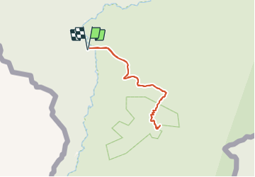
8.5 km | 16.1 km-effort
Unknown
Yes


Close
My subscriptions