


chapelle

LUCIE2016
User
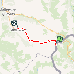

Length
11.7 km

Max alt
2883 m

Uphill gradient
78 m
Km-Effort
15.4 km

Min alt
2027 m

Downhill gradient
895 m
Boucle
No
Creation date :
2019-09-05 10:05:40.535
Updated on :
2019-09-06 06:41:10.324
3h55
Difficulty : Difficult

FREE GPS app for hiking
 SityTrail
IGN / Geographical institutes
SityTrail Plus
The world is yours!
About
Trail Walking of 11.7 km to be discovered at Piemont, Cuneo, Pontechianale. This trail is proposed by LUCIE2016.
Positioning
Country:
Italy
Region :
Piemont
Department/Province :
Cuneo
Municipality :
Pontechianale
Location:
Unknown
Start:(Dec)
Start:(UTM)
338173 ; 4948609 (32T) N.
Comments