


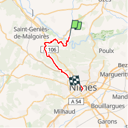
Régordane 8 - Ste Anastasie-Nimes

nolsim
User

Length
28 km

Max alt
179 m

Uphill gradient
400 m
Km-Effort
33 km

Min alt
43 m

Downhill gradient
433 m
Boucle
No
Creation date :
2019-09-06 06:07:39.063
Updated on :
2019-09-06 14:11:26.416
8h02
Difficulty : Easy

FREE GPS app for hiking
 SityTrail
IGN / Geographical institutes
SityTrail Plus
The world is yours!
About
Trail Walking of 28 km to be discovered at Occitania, Gard, Sainte-Anastasie. This trail is proposed by nolsim.
Description
Parcours monotone mais belle arrivée sur Nîmes
Photos


Positioning
Country:
France
Region :
Occitania
Department/Province :
Gard
Municipality :
Sainte-Anastasie
Location:
Unknown
Start:(Dec)
Start:(UTM)
606197 ; 4865827 (31T) N.
Comments