


rando Marie 8-19

Bastiere
User

Length
12.2 km

Max alt
408 m

Uphill gradient
391 m
Km-Effort
17.4 km

Min alt
222 m

Downhill gradient
389 m
Boucle
No
Creation date :
2019-09-08 11:02:04.778
Updated on :
2019-09-08 14:25:57.617
2h47
Difficulty : Medium

FREE GPS app for hiking
 SityTrail
IGN / Geographical institutes
SityTrail Plus
The world is yours!
About
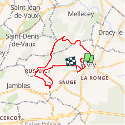
Trail Walking of 12.2 km to be discovered at Bourgogne-Franche-Comté, Saône-et-Loire, Givry. This trail is proposed by Bastiere.
Positioning
Country:
France
Region :
Bourgogne-Franche-Comté
Department/Province :
Saône-et-Loire
Municipality :
Givry
Location:
Unknown
Start:(Dec)
Start:(UTM)
632752 ; 5182295 (31T) N.
Comments