


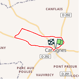
Cahagnes Géocaching

yannick-p
User

Length
4.7 km

Max alt
181 m

Uphill gradient
36 m
Km-Effort
5.2 km

Min alt
157 m

Downhill gradient
36 m
Boucle
Yes
Creation date :
2019-09-08 20:05:20.599
Updated on :
2019-09-08 20:07:41.78
1h00
Difficulty : Easy

FREE GPS app for hiking
 SityTrail
IGN / Geographical institutes
SityTrail Plus
The world is yours!
About
Trail Geocaching of 4.7 km to be discovered at Normandy, Calvados, Cahagnes. This trail is proposed by yannick-p.
Positioning
Country:
France
Region :
Normandy
Department/Province :
Calvados
Municipality :
Cahagnes
Location:
Unknown
Start:(Dec)
Start:(UTM)
663041 ; 5437222 (30U) N.
Comments