


entrainement vertical

trailer38
User
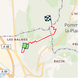

Length
2.7 km

Max alt
918 m

Uphill gradient
711 m
Km-Effort
9.8 km

Min alt
197 m

Downhill gradient
0 m
Boucle
No
Creation date :
2019-09-09 06:37:26.59
Updated on :
2019-09-09 06:40:51.742
45m
Difficulty : Medium

FREE GPS app for hiking
 SityTrail
IGN / Geographical institutes
SityTrail Plus
The world is yours!
About
Trail Trail of 2.7 km to be discovered at Auvergne-Rhône-Alpes, Isère, Voreppe. This trail is proposed by trailer38.
Positioning
Country:
France
Region :
Auvergne-Rhône-Alpes
Department/Province :
Isère
Municipality :
Voreppe
Location:
Unknown
Start:(Dec)
Start:(UTM)
705874 ; 5020482 (31T) N.
Comments