


Sentier des costes

mysterdub
User
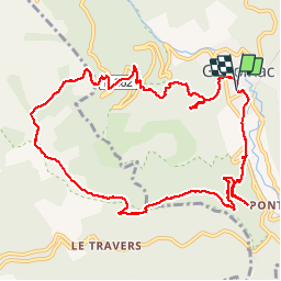

Length
12 km

Max alt
899 m

Uphill gradient
514 m
Km-Effort
18.9 km

Min alt
448 m

Downhill gradient
516 m
Boucle
Yes
Creation date :
2019-09-09 07:25:33.289
Updated on :
2019-09-09 11:09:41.215
3h30
Difficulty : Very easy

FREE GPS app for hiking
 SityTrail
IGN / Geographical institutes
SityTrail Plus
The world is yours!
About
Trail Walking of 12 km to be discovered at Occitania, Gard, Génolhac. This trail is proposed by mysterdub.
Positioning
Country:
France
Region :
Occitania
Department/Province :
Gard
Municipality :
Génolhac
Location:
Unknown
Start:(Dec)
Start:(UTM)
575680 ; 4911069 (31T) N.
Comments