


difficile

raygautier
User
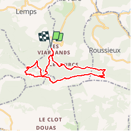

Length
14.5 km

Max alt
1372 m

Uphill gradient
910 m
Km-Effort
27 km

Min alt
832 m

Downhill gradient
910 m
Boucle
Yes
Creation date :
2019-09-10 07:56:34.859
Updated on :
2019-09-10 07:57:39.102
5h21
Difficulty : Very difficult

FREE GPS app for hiking
 SityTrail
IGN / Geographical institutes
SityTrail Plus
The world is yours!
About
Trail Walking of 14.5 km to be discovered at Auvergne-Rhône-Alpes, Drôme, Montferrand-la-Fare. This trail is proposed by raygautier.
Description
rando cool
Positioning
Country:
France
Region :
Auvergne-Rhône-Alpes
Department/Province :
Drôme
Municipality :
Montferrand-la-Fare
Location:
Unknown
Start:(Dec)
Start:(UTM)
694260 ; 4911856 (31T) N.
Comments