


Paiolive 28 août 2019

elorthiois
User
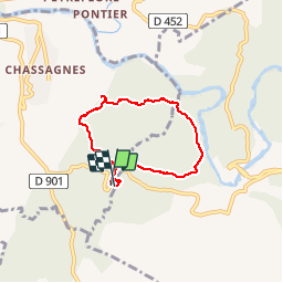

Length
5.5 km

Max alt
251 m

Uphill gradient
101 m
Km-Effort
6.9 km

Min alt
182 m

Downhill gradient
104 m
Boucle
Yes
Creation date :
2019-08-28 06:15:55.827
Updated on :
2019-09-10 08:22:45.59
3h23
Difficulty : Easy

FREE GPS app for hiking
 SityTrail
IGN / Geographical institutes
SityTrail Plus
The world is yours!
About
Trail Walking of 5.5 km to be discovered at Auvergne-Rhône-Alpes, Ardèche, Les Vans. This trail is proposed by elorthiois.
Positioning
Country:
France
Region :
Auvergne-Rhône-Alpes
Department/Province :
Ardèche
Municipality :
Les Vans
Location:
Chassagnes
Start:(Dec)
Start:(UTM)
593812 ; 4916382 (31T) N.
Comments