


190910 Bourron

randodan
User
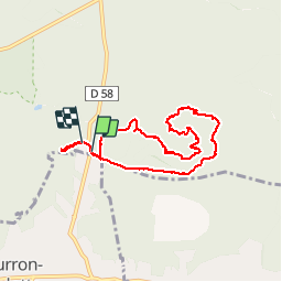

Length
6.9 km

Max alt
138 m

Uphill gradient
115 m
Km-Effort
8.4 km

Min alt
92 m

Downhill gradient
107 m
Boucle
Yes
Creation date :
2019-09-10 07:35:48.983
Updated on :
2019-09-12 12:06:37.668
3h02
Difficulty : Very easy

FREE GPS app for hiking
 SityTrail
IGN / Geographical institutes
SityTrail Plus
The world is yours!
About
Trail Walking of 6.9 km to be discovered at Ile-de-France, Seine-et-Marne, Fontainebleau. This trail is proposed by randodan.
Positioning
Country:
France
Region :
Ile-de-France
Department/Province :
Seine-et-Marne
Municipality :
Fontainebleau
Location:
Unknown
Start:(Dec)
Start:(UTM)
479167 ; 5355649 (31U) N.
Comments