


st etienne chalaronne

jpfrobert
User

Length
25 km

Max alt
262 m

Uphill gradient
270 m
Km-Effort
29 km

Min alt
182 m

Downhill gradient
270 m
Boucle
Yes
Creation date :
2019-09-10 13:47:59.373
Updated on :
2019-09-10 14:13:16.256
1h55
Difficulty : Medium

FREE GPS app for hiking
 SityTrail
IGN / Geographical institutes
SityTrail Plus
The world is yours!
About
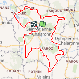
Trail Mountain bike of 25 km to be discovered at Auvergne-Rhône-Alpes, Ain, Saint-Étienne-sur-Chalaronne. This trail is proposed by jpfrobert.
Positioning
Country:
France
Region :
Auvergne-Rhône-Alpes
Department/Province :
Ain
Municipality :
Saint-Étienne-sur-Chalaronne
Location:
Unknown
Start:(Dec)
Start:(UTM)
644050 ; 5112156 (31T) N.
Comments