


La maurelle laval

albert318
User
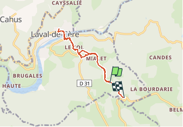

Length
6.8 km

Max alt
509 m

Uphill gradient
354 m
Km-Effort
11.3 km

Min alt
166 m

Downhill gradient
300 m
Boucle
No
Creation date :
2014-12-10 00:00:00.0
Updated on :
2014-12-10 00:00:00.0
1h29
Difficulty : Medium

FREE GPS app for hiking
 SityTrail
IGN / Geographical institutes
SityTrail Plus
The world is yours!
About
Trail Walking of 6.8 km to be discovered at Occitania, Lot, Laval-de-Cère. This trail is proposed by albert318.
Description
Aller à l' épicerie
Positioning
Country:
France
Region :
Occitania
Department/Province :
Lot
Municipality :
Laval-de-Cère
Location:
Unknown
Start:(Dec)
Start:(UTM)
417366 ; 4976922 (31T) N.
Comments