


2019-09-11 Rando Breuillet

jchezlemas
User
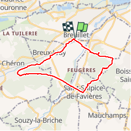

Length
12.7 km

Max alt
157 m

Uphill gradient
248 m
Km-Effort
16 km

Min alt
56 m

Downhill gradient
249 m
Boucle
Yes
Creation date :
2019-09-11 06:59:02.375
Updated on :
2019-09-11 13:43:05.34
3h33
Difficulty : Easy

FREE GPS app for hiking
 SityTrail
IGN / Geographical institutes
SityTrail Plus
The world is yours!
About
Trail Walking of 12.7 km to be discovered at Ile-de-France, Essonne, Breuillet. This trail is proposed by jchezlemas.
Description
Rando de Martine et Alain Gauthier
Office de Tourisme de l'Arpajonnais
http://ot-arpajonnais.fr/
Positioning
Country:
France
Region :
Ile-de-France
Department/Province :
Essonne
Municipality :
Breuillet
Location:
Unknown
Start:(Dec)
Start:(UTM)
438966 ; 5379425 (31U) N.
Comments