


2019 09 PROVINS T2

michel1025
User
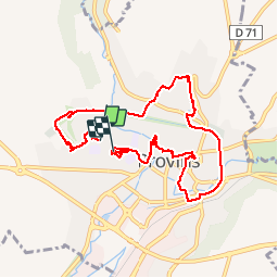

Length
8.9 km

Max alt
139 m

Uphill gradient
102 m
Km-Effort
10.2 km

Min alt
89 m

Downhill gradient
107 m
Boucle
No
Creation date :
2019-09-11 11:39:44.0
Updated on :
2019-09-11 14:14:53.643
2h36
Difficulty : Unknown

FREE GPS app for hiking
 SityTrail
IGN / Geographical institutes
SityTrail Plus
The world is yours!
About
Trail Walking of 8.9 km to be discovered at Ile-de-France, Seine-et-Marne, Provins. This trail is proposed by michel1025.
Positioning
Country:
France
Region :
Ile-de-France
Department/Province :
Seine-et-Marne
Municipality :
Provins
Location:
Unknown
Start:(Dec)
Start:(UTM)
521244 ; 5378847 (31U) N.
Comments