


lanvenegen faouet

lilwenn
User
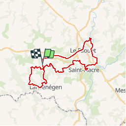

Length
29 km

Max alt
189 m

Uphill gradient
651 m
Km-Effort
37 km

Min alt
60 m

Downhill gradient
644 m
Boucle
Yes
Creation date :
2019-09-12 13:46:49.683
Updated on :
2019-09-15 07:41:50.57
--
Difficulty : Medium

FREE GPS app for hiking
 SityTrail
IGN / Geographical institutes
SityTrail Plus
The world is yours!
About
Trail Equestrian of 29 km to be discovered at Brittany, Morbihan, Lanvénégen. This trail is proposed by lilwenn.
Positioning
Country:
France
Region :
Brittany
Department/Province :
Morbihan
Municipality :
Lanvénégen
Location:
Unknown
Start:(Dec)
Start:(UTM)
459250 ; 5318535 (30U) N.
Comments