


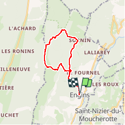
Engins - Col de la Molière

maupassant38
User

Length
12.7 km

Max alt
1644 m

Uphill gradient
756 m
Km-Effort
23 km

Min alt
924 m

Downhill gradient
757 m
Boucle
Yes
Creation date :
2019-09-12 08:29:52.496
Updated on :
2019-09-12 14:18:54.902
3h17
Difficulty : Medium

FREE GPS app for hiking
 SityTrail
IGN / Geographical institutes
SityTrail Plus
The world is yours!
About
Trail Walking of 12.7 km to be discovered at Auvergne-Rhône-Alpes, Isère, Engins. This trail is proposed by maupassant38.
Positioning
Country:
France
Region :
Auvergne-Rhône-Alpes
Department/Province :
Isère
Municipality :
Engins
Location:
Unknown
Start:(Dec)
Start:(UTM)
705612 ; 5006434 (31T) N.
Comments