


120919 marsat

cmar
User
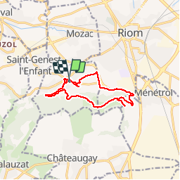

Length
12.2 km

Max alt
457 m

Uphill gradient
222 m
Km-Effort
15.2 km

Min alt
339 m

Downhill gradient
226 m
Boucle
Yes
Creation date :
2019-09-12 11:33:20.0
Updated on :
2019-09-12 15:45:03.163
4h09
Difficulty : Unknown

FREE GPS app for hiking
 SityTrail
IGN / Geographical institutes
SityTrail Plus
The world is yours!
About
Trail Walking of 12.2 km to be discovered at Auvergne-Rhône-Alpes, Puy-de-Dôme, Marsat. This trail is proposed by cmar.
Positioning
Country:
France
Region :
Auvergne-Rhône-Alpes
Department/Province :
Puy-de-Dôme
Municipality :
Marsat
Location:
Unknown
Start:(Dec)
Start:(UTM)
506480 ; 5080285 (31T) N.
Comments