


maranville

DaVinci
User
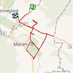

Length
10 km

Max alt
241 m

Uphill gradient
99 m
Km-Effort
11.4 km

Min alt
198 m

Downhill gradient
114 m
Boucle
No
Creation date :
2019-09-13 07:10:39.919
Updated on :
2019-09-13 09:06:10.658
1h55
Difficulty : Very easy

FREE GPS app for hiking
 SityTrail
IGN / Geographical institutes
SityTrail Plus
The world is yours!
About
Trail Walking of 10 km to be discovered at Grand Est, Haute-Marne, Rennepont. This trail is proposed by DaVinci.
Photos


29 photos in total. Please click on a photo to see them all in the gallery.
Positioning
Country:
France
Region :
Grand Est
Department/Province :
Haute-Marne
Municipality :
Rennepont
Location:
Unknown
Start:(Dec)
Start:(UTM)
639079 ; 5334313 (31U) N.
Comments