


Chenaillet

Spinnaker
User

Length
10.1 km

Max alt
2361 m

Uphill gradient
536 m
Km-Effort
17 km

Min alt
1852 m

Downhill gradient
472 m
Boucle
No
Creation date :
2019-09-14 06:24:43.983
Updated on :
2019-09-14 14:03:16.683
4h58
Difficulty : Very easy

FREE GPS app for hiking
 SityTrail
IGN / Geographical institutes
SityTrail Plus
The world is yours!
About
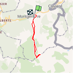
Trail Walking of 10.1 km to be discovered at Provence-Alpes-Côte d'Azur, Hautes-Alpes, Montgenèvre. This trail is proposed by Spinnaker.
Positioning
Country:
France
Region :
Provence-Alpes-Côte d'Azur
Department/Province :
Hautes-Alpes
Municipality :
Montgenèvre
Location:
Unknown
Start:(Dec)
Start:(UTM)
320528 ; 4977841 (32T) N.
Comments