


20110331-Radepont

doudet
User
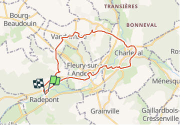

Length
15 km

Max alt
132 m

Uphill gradient
289 m
Km-Effort
18.9 km

Min alt
21 m

Downhill gradient
286 m
Boucle
Yes
Creation date :
2019-09-15 06:47:46.851
Updated on :
2019-09-15 06:47:46.851
--
Difficulty : Unknown

FREE GPS app for hiking
 SityTrail
IGN / Geographical institutes
SityTrail Plus
The world is yours!
About
Trail On foot of 15 km to be discovered at Normandy, Eure, Radepont. This trail is proposed by doudet.
Positioning
Country:
France
Region :
Normandy
Department/Province :
Eure
Municipality :
Radepont
Location:
Unknown
Start:(Dec)
Start:(UTM)
378597 ; 5468222 (31U) N.
Comments